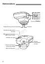
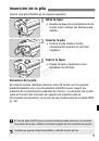
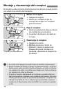
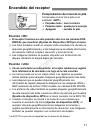
Доступность: Бесплатно как и все руководства на сайте. Без регистрации и SMS.
Дополнительно: Чтение инструкции онлайн
7
™
™
™
™
COP
Y
Страница: (9 из 292)
навигация
1
2
3
4
5
6
7
8
9
10
11
12
13
14
15
16
17
18
19
20
21
22
23
24
25
26
27
28
29
30
31
32
33
34
35
36
37
38
39
40
41
42
43
44
45
46
47
48
49
50
51
52
53
54
55
56
57
58
59
60
61
62
63
64
65
66
67
68
69
70
71
72
73
74
75
76
77
78
79
80
81
82
83
84
85
86
87
88
89
90
91
92
93
94
95
96
97
98
99
100
101
102
103
104
105
106
107
108
109
110
111
112
113
114
115
116
117
118
119
120
121
122
123
124
125
126
127
128
129
130
131
132
133
134
135
136
137
138
139
140
141
142
143
144
145
146
147
148
149
150
151
152
153
154
155
156
157
158
159
160
161
162
163
164
165
166
167
168
169
170
171
172
173
174
175
176
177
178
179
180
181
182
183
184
185
186
187
188
189
190
191
192
193
194
195
196
197
198
199
200
201
202
203
204
205
206
207
208
209
210
211
212
213
214
215
216
217
218
219
220
221
222
223
224
225
226
227
228
229
230
231
232
233
234
235
236
237
238
239
240
241
242
243
244
245
246
247
248
249
250
251
252
253
254
255
256
257
258
259
260
261
262
263
264
265
266
267
268
269
270
271
272
273
274
275
276
277
278
279
280
281
282
283
284
285
286
287
288
289
290
291
292
Оглавление инструкции
Страница 1 из 293 CANON INC. 30-2, Shimomaruko 3-chome, Ohta-ku, Tokyo 146-8501, Japan U.S.A. CANON U.S.A. INC. One Canon Plaza, Lake Success, NY 11042-1198, U.S.A. For all inquires concerning this product, call toll free in the U.S. 1-800-OK-CANON CANADA CANON CANADA INC. HEADQUARTERS 6390 Dixie Road, Mississauga,
Страница 36 из 293 Introduction The GPS Receiver GP-E2 can geotag your shots and record the route you travel. Using the provided software Map Utility, you can view shooting locations and the route traveled. The receiver can also set the camera time via GPS. Before Use Before use, check whether your camera menu
Страница 37 из 293 Features Geotagging Images and Adding the Shooting Direction Supported by cameras that display [GPS device settings] in the menu. Shots taken while the receiver is attached to the camera are geotagged, adding location information*1 (latitude, longitude, elevation, and shooting time (UTC*2)) to
Страница 38 из 293 Features Setting the Camera Time Supported by cameras that display [GPS device settings] in the menu, except the EOS 7D. The camera time can be set using GPS signals. On the EOS-1D X, high-precision adjustment is performed with a margin of error of approx. ±0.02 second relative to UTC time, and on
Страница 39 из 293 Item Checklist GP-E2 Carrying case Storage case Connecting cables Approx. 25 cm / 9.8 in. GPS Receiver Solution Disk (Software and instruction manuals) Approx. 1.5 m / 4.9 ft. PY O C Instruction Manual (this guide) Regulation leaflet Storage and Carrying Cases Before using the storage case, insert
Страница 40 из 293 Contents Introduction....................................................................................... 2 Features ........................................................................................... 3 Item
Страница 41 из 293 Conventions Used in this Manual Meaning of Symbols : Warning to prevent shooting problems. : Supplemental information. (p.**) : Reference page numbers for more information. The icons and markings indicating the receiver’s controls and settings used in the manual correspond to the icons and marking
Страница 42 из 293 Nomenclature <C> terminal Mounting foot locking pin Signal acquisition indicator <ON>: Power switch/ <LOG>: Logging switch Contacts PY O C Battery indicator Mounting foot locking lever Release button 8 Battery compartment cover
Страница 43 из 293 Inserting the Battery Insert one AA/LR6 battery as follows. 1 Open the cover. Slide the battery compartment cover as shown by the arrows to open the cover. the battery. 2 Insert Insert the battery with the negative terminal first, all the way in. the cover. 3 Close Close the cover and slide it as
Страница 44 из 293 Attaching and Detaching the Receiver The receiver can either be attached directly to your camera or carried with you in the carrying case. 1 Attach the receiver. Turn off the receiver. Insert the receiver’s mounting foot fully into the hot shoe. the receiver. 2 Secure Slide the mounting foot
Страница 45 из 293 Turning the Receiver On Checking the battery level Check the battery level on the <BATT.> indicator. Slow blinking : Level OK Fast blinking : Little power left Off : Replace battery <ON> Position The receiver functions in this position only with EOS DIGITAL cameras that display [GPS device
Страница 46 из 293 Acquiring GPS Signals To acquire GPS signals, bring the receiver outdoors where the sky is unobstructed and aim it up. Keep your hand or other objects off the top of the receiver. Turn the power switch to <ON> or <LOG> to start automatic GPS signal acquisition. To check the acquisition status,
Страница 47 из 293 Acquiring GPS Signals Places with Poor GPS Coverage Location information may not be recorded, or inaccurate information may be recorded where GPS signal coverage is poor, such as in the following places. Indoors, underground, near buildings or in valleys, in tunnels or forests Near high-voltage
Страница 48 из 293 Acquiring GPS Signals Viewing GPS Information Check GPS information as follows when the receiver is attached or connected to a camera that displays [GPS device settings] in the menu. 1 Select [GPS device settings]. On the EOS-1D X and other models that display the following screen, set [GPS device]
Страница 49 из 293 Geotagging Images as You Shoot When the receiver is attached or connected to a camera that displays the [GPS device settings] menu item, images are geotagged as you shoot. On cameras other than the EOS 7D, simply shoot with the receiver attached to your camera. Images can also be tagged with the
Страница 50 из 293 Logging the Route Traveled Setting the power switch to <LOG> will automatically record location information along the route traveled on the receiver itself. (There is no need to connect the receiver to the camera.) The recorded location information can be viewed on a virtual map. Logs can also be
Страница 51 из 293 Logging the Route Traveled Location Information Logs Location information is recorded at regular intervals along the route traveled with the receiver, as shown in the positioning interval table. Daily logs (p.24) are saved on the receiver itself. The number of days for which you can store logs
Страница 52 из 293 Setting the Positioning Interval You can specify the positioning interval when the receiver is attached or connected to a camera that displays the [GPS device settings] menu item. Shorter positioning intervals yield more accurate location information for your images. However, this also consumes
Страница 53 из 293 Setting the Positioning Interval Estimated Battery Life, by Positioning Interval Position Update Timing Battery Life (Approx.) Position Update Timing Battery Life (Approx.) Every second 10 hours Every 30 sec. 39 hours Every 5 sec. 27 hours Every minute 54 hours Every 10 sec. 37 hours Every 2 min.
Страница 54 из 293 Using the Digital Compass When the receiver is attached or connected to a camera that displays [GPS device settings] in the menu or mounted on a bracket (p.28), images are tagged with the direction the receiver is facing (except on the EOS 7D). 1 Select [GPS device settings]. On the EOS-1D X and
Страница 55 из 293 Using the Digital Compass Calibrating the Digital Compass Calibrate the digital compass at the shooting location. Also calibrate the compass if the direction shown as you shoot seems incorrect. 1 Select [GPS device settings]. On the EOS-1D X and other models that display the following screen, set
Страница 56 из 293 Using the Digital Compass the camera. 4 Move c Wave the camera laterally in at least a 180° arc. d Wave the camera up and down in at least a 180° arc. e Rotate the camera in at least a 180° arc as it faces the same direction. Be careful not to drop the camera during calibration. Steps c, d, and e
Страница 57 из 293 Setting Time from GPS on the Camera You can set the time from GPS when the receiver is attached or connected to a camera that displays the [GPS device settings] menu item (except on the EOS 7D). The EOS-1D X performs high-precision adjustment with a margin of error of approx. ±0.02 second relative
Страница 58 из 293 GPS Precautions Keep the following points in mind when using the receiver. In certain countries and regions, the use of GPS may be restricted. Therefore, be sure to use GPS in accordance with the laws and regulations of your country or region. Be particularly careful when traveling outside your
Страница 59 из 293 Provided Software Software on the provided solution disc is described below, with installations instructions. GPS Receiver Solution Disk Includes receiver software and the instruction manual. Map Utility This software uses location information recorded by the receiver to show shooting locations,
Страница 60 из 293 Provided Software Installing the Software Follow these steps even if an older version of the software is already installed. (The previous version will be overwritten, as needed.) 1 Insert the GPS Receiver Solution Disk in the computer. 2 Double-click the CD-ROM icon. Windows: This icon is displayed
Страница 61 из 293 Provided Software Copying and Viewing the PDF Instruction Manual 1 Insert the GPS Receiver Solution Disk in the computer. 2 Double-click the CD-ROM icon. Windows: This icon is displayed in [Computer] or [My Computer]. Macintosh: This icon is displayed on the desktop. 3 Double-click the [Manual]
Страница 62 из 293 Using a Bracket (Sold Separately) Attaching the Accessory Bracket AB-E1 (sold separately) enables you to use the receiver and an external or built-in flash at the same time. Attach the camera and receiver to the bracket as shown. Keep the camera aligned with the bracket during attachment. Even a
Страница 63 из 293 Specifications Compatible cameras EOS DIGITAL cameras * Cameras with [GPS device settings] menu item: All features available * Cameras without [GPS device settings] menu item: <LOG> mode available Geotagging Images Latitude, longitude, elevation, direction, time (UTC) and signal acquisition *
Страница 64 из 293 Safety Precautions The following precautions are intended to prevent harm to you and others as well as damage to equipment. Become familiar with the precautions before using the receiver to ensure correct and safe operation. Warning Preventing Serious Injury or Death To prevent fire, excessive
Страница 65 из 293 Safety Precautions Caution Preventing Injury or Equipment Damage Do not leave the receiver inside a vehicle in hot weather or near a heat source. The receiver may become hot and cause burns if touched. Do not use the receiver when it is covered by or wrapped in a cloth. This may trap heat inside,
Страница 66 из 293 The apparatus shall not be exposed to dripping or splashing. Batteries shall not be exposed to excessive heat such as sunshine, fire or the like. Dry batteries shall not be subjected to charging. European Union (and EEA) only. This symbol indicates that this product is not to be disposed of with
Страница 68 из 293 Introduction Le récepteur GPS GP-E2 peut géomarquer vos prises de vue et enregistrer l’itinéraire parcouru. En utilisant le logiciel Map Utility fourni, vous pouvez voir les emplacements de prise de vue et l’itinéraire parcouru. Le récepteur peut également régler l’heure de l’appareil photo via
Страница 69 из 293 Fonctionnalités Géomarquage des images et ajout de la direction de prise de vue Pris en charge par les appareils photo affichant [Réglages dispositif GPS] dans le menu. Les photos prises alors que le récepteur est fixé à l’appareil photo sont géomarquées avec l’ajout des informations sur
Страница 70 из 293 Fonctionnalités Réglage de l’heure de l’appareil photo Pris en charge par les appareils photo affichant [Réglages dispositif GPS] dans le menu, sauf l’EOS 7D. L’heure de l’appareil photo peut être réglée en utilisant les signaux GPS. Sur l’EOS-1D X, un réglage ultra-précis est réalisé avec une
Страница 71 из 293 Vérification des accessoires GP-E2 Étui de rangement Étui de transport Câbles de raccordement Environ 25 cm / 9,8 pouces GPS Receiver Solution Disk (Logiciels et modes d’emploi) Environ 1,5 m / 4,9 pieds PY O C Mode d’emploi (ce guide) Brochure sur les réglementations Étuis de rangement et de
Страница 72 из 293 Table des matières Introduction....................................................................................... 2 Fonctionnalités ................................................................................. 3 Vérification des
Страница 73 из 293 Conventions utilisées dans ce manuel Signification des symboles : Mise en garde pour éviter les problèmes de prise de vue. : Informations complémentaires. (p. **) : Numéros de page de référence pour obtenir de plus amples informations. Les icônes et repères indiquant les commandes et les réglages
Страница 74 из 293 Nomenclature Connecteur <C> Griffe de verrouillage du sabot de fixation Témoin d’acquisition de signaux <ON> : Bouton d’alimentation/ <LOG> : Bouton de journalisation Contacts PY O C Témoin de la pile Taquet de verrouillage du sabot de fixation Bouton de dégagement 8 Couvercle du compartiment à
Страница 75 из 293 Insertion de la pile Insérez comme suit une pile AA/LR6. 1 Ouvrez le couvercle. Faites glisser le couvercle du compartiment à pile dans le sens des flèches pour ouvrir le couvercle. la pile. 2 Insérez Insérez à fond la pile avec la borne négative en premier. le couvercle. 3 Fermez Fermez le
Страница 76 из 293 Fixation et retrait du récepteur Vous pouvez fixer directement le récepteur à l’appareil photo ou l’emporter avec vous dans l’étui de transport. 1 Fixez le récepteur. Éteignez le récepteur. Insérez complètement le sabot de fixation du récepteur dans la griffe porte-accessoires. solidement le
Страница 77 из 293 Mise sous tension du récepteur Vérification du niveau de la pile Vérifiez le niveau de la pile sur le témoin <BATT.>. Clignotement lent : Niveau suffisant Clignotement rapide : Niveau faible Éteint : Remplacez la pile Position <ON> Le récepteur ne fonctionne dans cette position qu’avec les
Страница 78 из 293 Acquisition des signaux GPS Pour acquérir les signaux GPS, il est nécessaire que le récepteur soit à l’extérieur sous un ciel dégagé et dirigé vers le haut. Éloignez votre main ou d’autres objets du haut du récepteur. Placez le bouton d’alimentation sur <ON> ou <LOG> pour lancer l’acquisition
Страница 79 из 293 Acquisition des signaux GPS Endroits avec une faible couverture GPS Les informations sur l’emplacement peuvent ne pas être enregistrées ou des informations inexactes peuvent être enregistrées dans les endroits où la réception des signaux GPS est faible, par exemple, dans les endroits suivants : À
Страница 80 из 293 Acquisition des signaux GPS Consultation des informations GPS Vérifiez les informations GPS comme suit lorsque le récepteur est fixé ou raccordé à un appareil photo affichant [Réglages dispositif GPS] dans le menu. 1 Sélectionnez [Réglages dispositif GPS]. Sur l’EOS-1D X et d’autres modèles
Страница 81 из 293 Géomarquage des images à mesure qu’elles sont prises Lorsque le récepteur est fixé ou raccordé à un appareil photo affichant l’élément de menu [Réglages dispositif GPS], les images sont géomarquées à mesure qu’elles sont prises. Sur les appareils photo autres que l’EOS 7D, il suffit de
Страница 82 из 293 Journalisation de l’itinéraire parcouru Si vous placez le bouton d’alimentation sur <LOG>, les informations sur l’emplacement sont automatiquement enregistrées tout au long de l’itinéraire parcouru directement sur le récepteur. (Il n’est pas nécessaire de raccorder le récepteur à l’appareil photo.)
Страница 83 из 293 Journalisation de l’itinéraire parcouru Fichiers journaux des informations sur l’emplacement Les informations sur l’emplacement sont enregistrées à intervalle régulier le long de l’itinéraire parcouru avec le récepteur, comme illustré dans le tableau des intervalles de positionnement. Les fichiers
Страница 84 из 293 Réglage de l’intervalle de positionnement Vous pouvez spécifier l’intervalle de positionnement lorsque le récepteur est fixé ou raccordé à un appareil photo affichant l’élément de menu [Réglages dispositif GPS]. Les intervalles de positionnement plus courts produisent des informations sur
Страница 85 из 293 Réglage de l’intervalle de positionnement Estimation de la durée de vie de la pile, par intervalle de positionnement Mise à jour de la position Durée de vie de la pile (approx.) Mise à jour de la position Durée de vie de la pile (approx.) Toutes les secondes 10 heures Toutes les 30 secondes 39
Страница 86 из 293 Utilisation de la boussole numérique Lorsque le récepteur est fixé ou raccordé à un appareil photo affichant [Réglages dispositif GPS] dans le menu ou monté sur une barrette (p. 28), les images sont marquées avec la direction dans laquelle le récepteur est tourné (sauf sur l’EOS 7D). 1 Sélectionnez
Страница 87 из 293 Utilisation de la boussole numérique Calibrage de la boussole numérique Calibrez la boussole numérique sur l’emplacement de prise de vue. Calibrez également la boussole si la direction indiquée lors de la prise de vue semble incorrecte. 1 Sélectionnez [Réglages dispositif GPS]. Sur l’EOS-1D X et
Страница 88 из 293 Utilisation de la boussole numérique l’appareil photo. 4 Bougez c Déplacez l’appareil photo latéralement en formant un arc d’au moins 180°. d Déplacez l’appareil photo de haut en bas en formant un arc d’au moins 180°. e Faites pivoter l’appareil photo toujours tourné dans le même sens en formant un
Страница 89 из 293 Réglage de l’heure depuis le GPS sur l’appareil photo Vous pouvez régler l’heure depuis le GPS lorsque le récepteur est fixé ou raccordé à un appareil photo affichant l’élément de menu [Réglages dispositif GPS] (sauf sur l’EOS 7D). L’EOS-1D X exécute un réglage ultra-précis avec une marge d’erreur
Страница 90 из 293 Précautions relatives au GPS Gardez les points suivants à l’esprit lorsque vous utilisez le récepteur. Dans certains pays et régions, l’utilisation du GPS pouvant être limitée, veillez à respecter les lois et réglementations de votre pays ou région. Soyez particulièrement prudent lorsque vous
Страница 91 из 293 Logiciels fournis Les logiciels sur le disque de solution fourni sont présentés ci-dessous avec leurs instructions d’installation. GPS Receiver Solution Disk Comprend les logiciels du récepteur et le mode d’emploi. Map Utility Ce logiciel utilise les informations sur l’emplacement enregistrées par
Страница 92 из 293 Logiciels fournis Installation des logiciels Suivez ces étapes même si une version plus ancienne des logiciels est déjà installée. (La version précédente sera écrasée au besoin.) 1 Insérez le GPS Receiver Solution Disk dans l’ordinateur. 2 Double-cliquez sur l’icône de CD-ROM. Windows : Cette icône
Страница 93 из 293 Logiciels fournis Copie et visionnage du mode d’emploi au format PDF 1 Insérez le GPS Receiver Solution Disk dans l’ordinateur. 2 Double-cliquez sur l’icône de CD-ROM. Windows : Cette icône s’affiche dans [Poste de travail] ou [Ordinateur]. Macintosh : Cette icône s’affiche sur le bureau. 3
Страница 94 из 293 Utilisation d’une barrette (vendue séparément) Si vous fixez la barrette accessoire AB-E1 (vendue séparément), vous pouvez utiliser le récepteur et un flash externe ou intégré simultanément. Fixez l’appareil photo et le récepteur à la barrette comme suit. Maintenez l’appareil photo aligné avec la
Страница 95 из 293 Spécifications Appareils photo compatibles Appareils photo EOS DIGITAL Géomarquage des images Latitude, longitude, altitude, direction, heure (UTC) et acquisition du signal * Appareils photo avec l’élément de menu [Réglages dispositif GPS] : toutes les fonctionnalités sont disponibles * Appareils
Страница 96 из 293 Consignes de sécurité Les précautions suivantes ont pour but d’éviter que vous ou d’autres personnes ne se blessent et que l’appareil ne soit endommagé. Familiarisez-vous avec ces précautions avant d’utiliser le récepteur afin de garantir son bon fonctionnement en toute sécurité. Avertissement
Страница 97 из 293 Consignes de sécurité Attention Prévention des blessures ou des dégâts matériels Ne laissez pas le récepteur à l’intérieur d’un véhicule par temps chaud ou près d’une source de chaleur. Le récepteur peut chauffer et vous brûler si vous le touchez. N’utilisez pas le récepteur lorsqu’il est recouvert
Страница 98 из 293 Ne pas exposer l’appareil aux gouttes ni aux éclaboussements d’eau. Ne pas exposer les piles à une chaleur excessive, par exemple en plein soleil. Ne pas recharger des piles sèches. Union européenne (et EEE) uniquement. Ce symbole indique que, conformément à la directive DEEE (2002/96/CE) et à la
Страница 100 из 293 Einführung Der GPS Empfänger GP-E2 ermöglicht das Verknüpfen Ihrer Aufnahmen mit Geodaten („Geotagging“) und das Aufzeichnen Ihrer Reiseroute. Mit der mitgelieferten Software Map Utility können Sie sich die Aufnahmeorte und die zurückgelegte Route auf einer virtuellen Landkarte ansehen. Sie haben
Страница 101 из 293 Funktionen Geotagging von Bildern und Hinzufügen der Aufnahmerichtung Geotagging wird von Kameras unterstützt, die den Menüpunkt [GPSGeräteeinstellungen] anzeigen. Wenn der Empfänger mit der Kamera verbunden ist, werden den Bildern während der Aufnahme Geodaten hinzugefügt*1 (Breitengrad,
Страница 102 из 293 Funktionen Einstellen der Kamerazeit Geotagging wird von Kameras unterstützt, die den Menüpunkt [GPS-Geräteeinstellungen] anzeigen (außer EOS 7D). Die Kamerazeit lässt sich auch über GPS-Signale einstellen. Bei der EOS-1D X wird die Kamerazeit hochpräzise mit einer Fehlertoleranz von ca. ±0,02
Страница 103 из 293 Checkliste GP-E2 Tragetasche Aufbewahrungstasche Anschlusskabel ca. 1,5 m ca. 25 cm GPS Receiver Solution Disk (Software- und Bedienungsanleitungen) PY O C Bedienungsanleitung (diese Anleitung) Vorschriften (Merkblatt) Aufbewahrungstasche und Tragetasche Um den Empfänger nicht zu zerkratzen,
Страница 104 из 293 Inhalt Einführung ........................................................................................ 2 Funktionen........................................................................................ 3
Страница 105 из 293 Konventionen in dieser Bedienungsanleitung Bedeutung der Symbole : Warnt vor möglichen Problemen bei der Aufnahme. : Ergänzende Informationen (S.**) : Die Seitenzahlen in Klammern weisen auf weiterführende Informationen hin. Die Symbole und Markierungen in dieser Anleitung, die auf Bedienelemente
Страница 106 из 293 Teilebezeichnungen <C>-Anschluss Verriegelungsstift für Befestigungsfuß Signalanzeige <ON>: EIN/AUS-Schalter/ <LOG>: Logging-Schalter Kontakte PY O C Batterieanzeige Batteriefachabdeckung Verriegelungshebel für Befestigungsfuß Entriegelungsknopf 8
Страница 107 из 293 Einsetzen der Batterie Legen Sie eine AA/LR6-Batterie nach der folgenden Anleitung ein. 1 Öffnen Sie die Abdeckung. Schieben Sie die Batteriefachabdeckung in Pfeilrichtung, und öffnen Sie das Fach. Sie die Batterie ein. 2 Setzen Schieben Sie die Batterie mit dem Minuspol zuerst vollständig in das
Страница 108 из 293 Anbringen und Abnehmen des Empfängers Der Empfänger kann entweder direkt an der Kamera angebracht oder in der Tragetasche mitgeführt werden. 1 Bringen Sie den Empfänger an. Schalten Sie den Empfänger aus. Setzen Sie den Befestigungsfuß des Empfängers vollständig in den Zubehörschuh ein. Sie den
Страница 109 из 293 Einschalten des Empfängers Ladezustand der Batterie prüfen Überprüfen Sie auf der <BATT.>-Anzeige den Ladezustand der Batterie. Blinkt langsam : Ladezustand OK Blinkt schnell : Bald erschöpft Aus : Batterie ersetzen <ON>-Position Der Empfänger funktioniert in dieser Position nur mit EOS
Страница 110 из 293 GPS-Signalerfassung Zum Erfassen von GPS-Signalen gehen Sie mit dem Empfänger unter freien Himmel, und richten Sie ihn aufwärts. Die Oberseite des Empfängers darf nicht durch Ihre Hand oder durch Gegenstände verdeckt sein. Schalten Sie den EIN/AUS-Schalter auf <ON> oder <LOG>, um die automatische
Страница 111 из 293 GPS-Signalerfassung Orte mit schlechtem GPS-Empfang An Orten mit schlechtem GPS-Empfang werden die Geodaten möglicherweise ungenau oder gar nicht aufgezeichnet. Beispiele für ungünstige GPS-Empfangsbedingungen: In Innenräumen, in unterirdischen Bereichen, an Gebäuden oder in Tälern, in Tunneln oder
Страница 112 из 293 GPS-Signalerfassung Anzeigen von GPS-Informationen Wenn der Empfänger an einer Kamera angebracht bzw. angeschlossen ist, die den Menüpunkt [GPSGeräteeinstellungen] anzeigt, können Sie die GPS-Informationen folgendermaßen anzeigen. 1 Wählen Sie [GPSGeräteeinstellungen]. An der EOS-1D X und an
Страница 113 из 293 Geotagging von Bildern während der Aufnahme Wenn der Empfänger an einer Kamera angebracht bzw. angeschlossen ist, die den Menüpunkt [GPS-Geräteeinstellungen] anzeigt, werden den Bildern schon während der Aufnahme Geodaten hinzugefügt. Wenn Sie eine andere Kamera als die EOS 7D verwenden, machen Sie
Страница 114 из 293 Aufzeichnen der Reiseroute Wenn Sie den EIN/AUS-Schalter auf <LOG> stellen, zeichnet der Empfänger die Geodaten entlang der Reiseroute automatisch auf. (Sie brauchen den Empfänger nicht an der Kamera anzuschließen.) Die aufgezeichneten Geodaten können auf einer virtuellen Landkarte angezeigt
Страница 115 из 293 Aufzeichnen der Reiseroute Logs mit Geoinformationen Der Empfänger zeichnet die Geodaten entlang der Reiseroute in regelmäßigen Intervallen auf (siehe Tabelle mit den Positionsintervallen). Die täglichen Logs (S.24) werden auf dem Empfänger gespeichert. Die Anzahl der Tage, für die Sie Logs
Страница 116 из 293 Einstellen des Positionsintervalls Wenn der Empfänger an einer Kamera angebracht bzw. angeschlossen ist, die den Menüpunkt [GPS-Geräteeinstellungen] anzeigt, können Sie die Positionsintervalle angeben. Kürzere Positionsintervalle führen zu genaueren Ortsinformationen für Ihre Bilder. Dabei wird
Страница 117 из 293 Einstellen des Positionsintervalls Geschätzte Lebensdauer der Batterie, nach Positionsintervall Timing Positionsaktualisierung Lebensdauer der Batterie (ca.) Timing Positionsaktualisierung Lebensdauer der Batterie (ca.) Jede Sek. 10 Stunden Alle 30 Sek. 39 Stunden Alle 5 Sek. 27 Stunden Jede Min.
Страница 118 из 293 Verwenden des Digitalkompasses Wenn der Empfänger an einer Kamera angebracht bzw. angeschlossen ist, die den Menüpunkt [GPSGeräteeinstellungen] anzeigt, oder wenn der Empfänger an einem Zubehörhalter (S.28) montiert ist, werden die Bilder mit den Richtungsdaten des Empfängers gekennzeichnet (außer
Страница 119 из 293 Verwenden des Digitalkompasses Kalibrieren des Digitalkompasses Kalibrieren Sie den Digitalkompass am Aufnahmestandort. Außerdem muss der Kompass kalibriert werden, wenn Ihnen die angezeigte Richtung beim Aufnehmen nicht korrekt erscheint. 1 Wählen Sie [GPSGeräteeinstellungen]. An der EOS-1D X und
Страница 120 из 293 Verwenden des Digitalkompasses Sie die Kamera. 4 Bewegen c Schwenken Sie die Kamera seitlich in einem Bogen von mindestens 180°. d Schwenken Sie die Kamera nach oben und unten in einem Bogen von mindestens 180°. e Drehen Sie die Kamera in einem Bogen von mindestens 180°. Die Kamera zeigt dabei
Страница 121 из 293 Einstellen der Kamerazeit mit GPS Wenn der Empfänger an einer Kamera angebracht bzw. angeschlossen ist, die den Menüpunkt [GPS-Geräteeinstellungen] anzeigt, können Sie die Kamerazeit über GPS einstellen (außer EOS 7D). Bei der EOS-1D X wird die Kamerazeit hochpräzise mit einer Fehlertoleranz von
Страница 122 из 293 Wichtige Hinweise zu GPS Beachten Sie bei der Verwendung des Empfängers folgende Punkte: In bestimmten Ländern und Regionen ist die Verwendung von GPS eingeschränkt. Vergewissern Sie sich, dass Sie das GPS nur in Übereinstimmung mit den Gesetzen und Vorschriften Ihres Landes bzw. Ihrer Region
Страница 123 из 293 Mitgelieferte Software Im folgenden Abschnitt finden Sie die Beschreibung und die Installationsanweisungen zu der Software, die sich auf der mitgelieferten Software-CD befindet. GPS Receiver Solution Disk Enthält die Software des Empfängers und die Bedienungsanleitung. Map Utility Mit dieser
Страница 124 из 293 Mitgelieferte Software Installieren der Software Führen Sie die folgenden Schritte aus, auch wenn bereits eine ältere Version der Software installiert ist. (Die frühere Version wird gegebenenfalls überschrieben.) 1 Legen Sie die GPS Receiver Solution Disk in das DiscLaufwerk des Computers ein. 2
Страница 125 из 293 Mitgelieferte Software Kopieren und Anzeigen der PDF-Bedienungsanleitung 1 Legen Sie die GPS Receiver Solution Disk in das DiscLaufwerk des Computers ein. 2 Doppelklicken Sie auf das CD-ROM-Symbol. Windows: Dieses Symbol wird unter [Computer] oder [Arbeitsplatz] angezeigt. Macintosh: Dieses Symbol
Страница 126 из 293 Verwendung eines Halters (separat erhältlich) Durch Anbringen des Zubehörhalters AB-E1 (separat erhältlich) können Sie den Empfänger zusammen mit einem externen oder eingebauten Blitz verwenden. Befestigen Sie die Kamera und den Empfänger gemäß Abbildung an dem Zubehörhalter. Richten Sie die Kamera
Страница 127 из 293 Technische Daten Kompatible Kameras EOS DIGITAL-Kameras * Kameras mit dem Menüpunkt [GPSGeräteeinstellungen]: Alle Funktionen verfügbar * Kameras ohne den Menüpunkt [GPSGeräteeinstellungen]: <LOG>-Modus verfügbar Geotagging von Bildern Breitengrad, Längengrad, Höhe, Richtung, Koordinierte Weltzeit
Страница 128 из 293 Sicherheitshinweise Die folgenden Vorsichtsmaßnahmen dienen dazu, Verletzungen und Geräteschäden zu vermeiden. Machen Sie sich mit den Vorsichtsmaßnahmen vertraut, bevor Sie den Empfänger verwenden, um einen korrekten und sicheren Betrieb zu gewährleisten. Warnung Vermeiden von schweren
Страница 129 из 293 Sicherheitshinweise Vorsicht Vermeiden von Verletzungen und Geräteschäden Den Empfänger nicht bei Sonneneinstrahlung im Auto oder in der Nähe einer Wärmequelle ablegen. Der Empfänger kann heiß werden und Hautverbrennungen verursachen. Der Empfänger darf während des Betriebs nicht abgedeckt oder in
Страница 130 из 293 Hinweise für Deutschland Batterien und Akkumulatoren gehören nicht in den Hausmüll ! Im Interesse des Umweltschutzes sind Sie als Endverbraucher gesetzlich verpflichtet (Batterieverordnung), alte und gebrauchte Batterien und Akkumulatoren zurückzugeben. Sie können die gebrauchten Batterien an den
Страница 132 из 293 Introduzione Il Ricevitore GPS GP-E2 è in grado di eseguire la geolocalizzazione delle fotografie e di registrare i viaggi. Utilizzando il software Map Utility fornito in dotazione, è possibile visualizzare i luoghi di scatto e gli itinerari percorsi. Il ricevitore può anche impostare l’ora della
Страница 133 из 293 Funzioni Geolocalizzazione delle immagini e aggiunta della direzione di scatto Questa funzione è supportata dalle fotocamere con la voce [Impostazioni dispositivo GPS] nel menu. Quando il ricevitore è fissato alla fotocamera, le immagini vengono geolocalizzate con l’aggiunta di informazioni sulla
Страница 134 из 293 Funzioni Impostazione dell’ora della fotocamera Questa funzione è supportata dalle fotocamere con la voce [Impostazioni dispositivo GPS] nel menu, tranne il modello EOS 7D. L’ora della fotocamera può essere impostata usando i segnali GPS. Nel modello EOS-1D X viene effettuata una regolazione ad
Страница 135 из 293 Contenuto della confezione GP-E2 Custodia di trasporto Custodia di protezione Cavi di connessione Circa 1,5 m Circa 25 cm GPS Receiver Solution Disk (Software e manuali di istruzioni) PY O C Manuale di istruzioni (il presente manuale) Scheda normativa Custodie di protezione e di trasporto Per
Страница 136 из 293 Indice Introduzione...................................................................................... 2 Funzioni............................................................................................ 3 Contenuto della confezione..............................................................
Страница 137 из 293 Convenzioni utilizzate in questo manuale Significato dei simboli : Avvertenza che indica le operazioni da effettuare per evitare problemi di scatto. : Informazioni aggiuntive. (pag. **) : Numeri delle pagine di riferimento per maggiori informazioni. Le icone e i simboli usati nel manuale per
Страница 138 из 293 Nomenclatura Connettore <C> Perno di bloccaggio piede di montaggio Spia di acquisizione segnale <ON>: Interruttore di accensione/ <LOG>: Interruttore di logging Contatti PY O C Spia batteria Coperchio vano batteria Leva di bloccaggio piede di montaggio Pulsante di rilascio 8
Страница 139 из 293 Inserimento della batteria Inserire una batteria AA/LR6 procedendo come segue. 1 Aprire il coperchio. Aprire il coperchio del vano batteria facendolo scorrere nella direzione indicata dalle frecce. la batteria. 2 Inserire Inserire fino in fondo la batteria introducendone l’estremità con il polo
Страница 140 из 293 Montaggio e smontaggio del ricevitore Il ricevitore può essere montato direttamente sulla fotocamera o trasportato nell’apposita custodia. 1 Montare il ricevitore. Spegnere il ricevitore. Inserire fino in fondo il piede di montaggio del ricevitore nella sede per accessori. il ricevitore. 2 Fissare
Страница 141 из 293 Accensione del ricevitore Controllo del livello della batteria Controllare il livello della batteria sulla spia <BATT.>. Lampeggio lento : Livello OK Lampeggio rapido: Batteria quasi scarica Spento : Sostituire la batteria Posizione <ON> Il ricevitore funziona in questa posizione solamente con
Страница 142 из 293 Acquisizione del segnale GPS Per acquisire il segnale GPS, portare il ricevitore all’esterno, a cielo aperto, e puntarlo verso l’alto. Non tenere le mani o altri oggetti sopra il ricevitore. Per avviare l’acquisizione automatica del segnale GPS, portare l’interruttore di accensione in posizione
Страница 143 из 293 Acquisizione del segnale GPS Luoghi con scarsa copertura GPS Le informazioni sulla posizione potrebbero non venire registrate od essere imprecise dove la copertura GPS è scarsa, quali i luoghi seguenti. Interni, sottosuolo, vicino ad edifici oppure in valli, gallerie o foreste Vicino a linee ad
Страница 144 из 293 Acquisizione del segnale GPS Visualizzazione delle informazioni GPS Quando il ricevitore è montato o collegato a una fotocamera con la voce [Impostazioni dispositivo GPS] nel menu, per controllare le informazioni GPS, procedere come segue. 1 Selezionare [Impostazioni dispositivo GPS]. Nel modello
Страница 145 из 293 Geolocalizzazione delle immagini al momento dello scatto Quando il ricevitore è montato o collegato a una fotocamera con la voce [Impostazioni dispositivo GPS] nel menu, la geolocalizzazione delle immagini viene eseguito al momento dello scatto. Con le fotocamere diverse dal modello EOS 7D, è
Страница 146 из 293 Logging di un viaggio Portando l’interruttore di accensione in posizione <LOG>, le informazioni sulla posizione vengono registrate automaticamente nel ricevitore stesso nel corso del viaggio (non è necessario collegare il ricevitore alla fotocamera). Le informazioni sulla posizione registrate
Страница 147 из 293 Logging di un viaggio Registri delle informazioni sulla posizione Le informazioni sulla posizione vengono registrate dal ricevitore a intervalli regolari nel corso del viaggio, come illustrato nella tabella degli intervalli di posizionamento. I registri giornalieri (pag. 24) vengono memorizzati nel
Страница 148 из 293 Impostazione dell’intervallo di posizionamento Quando il ricevitore è montato o collegato a una fotocamera con la voce [Impostazioni dispositivo GPS] nel menu, è possibile specificare l’intervallo di posizionamento. Intervalli di posizionamento più brevi forniscono informazioni più precise sulla
Страница 149 из 293 Impostazione dell’intervallo di posizionamento Durata stimata della batteria, per intervallo di posizionamento Tempi di aggiornamento posizione Durata batteria (ca.) Tempi di aggiornamento posizione Ogni secondo 10 ore Ogni 30 sec. 39 ore Ogni 5 sec. 27 ore Ogni minuto 54 ore Ogni 10 sec. 37 ore
Страница 150 из 293 Uso della bussola digitale Quando il ricevitore è montato o collegato a una fotocamera con la voce [Impostazioni dispositivo GPS] nel menu o montato su una staffa (pag. 28), alle immagini viene aggiunta la direzione in cui è rivolto il ricevitore (tranne il modello EOS 7D). 1 Selezionare
Страница 151 из 293 Uso della bussola digitale Taratura della bussola digitale Tarare la bussola digitale nella località di ripresa. Tarare la bussola anche se la direzione indicata dalla bussola sembra essere incorretta. 1 Selezionare [Impostazioni dispositivo GPS]. Nel modello EOS-1D X e negli altri modelli che
Страница 152 из 293 Uso della bussola digitale la fotocamera. 4 Muovere c Fare oscillare la fotocamera lateralmente compiendo un arco di almeno 180°. d Fare oscillare la fotocamera in alto e in basso compiendo un arco di almeno 180°. e Ruotare la fotocamera compiendo un arco di almeno 180°, tenendola sempre rivolta
Страница 153 из 293 Impostazione dell’ora della fotocamera tramite GPS Quando il ricevitore è montato o collegato a una fotocamera con la voce [Impostazioni dispositivo GPS] nel menu, è possibile impostare l’ora tramite GPS (tranne il modello EOS 7D). Nel modello EOS-1D X viene effettuata una regolazione ad alta
Страница 154 из 293 Precauzioni per l’uso del sistema GPS Durante l’uso del ricevitore, tenere a mente quanto segue. In alcuni Paesi e Regioni, l’utilizzo del GPS potrebbe essere soggetto a limitazioni. Assicurarsi perciò di usare il GPS nel rispetto delle leggi e disposizioni del proprio Paese o Regione. Prestare
Страница 155 из 293 Software fornito Di seguito è descritto il software contenuto nel disco fornito, con le relative istruzioni di installazione. GPS Receiver Solution Disk Include il software per il ricevitore e il manuale di istruzioni. Map Utility Questo software utilizza le informazioni sulla posizione registrate
Страница 156 из 293 Software fornito Installazione del software Seguire questi passaggi anche se è già installata una versione precedente del software (la versione precedente verrà sovrascritta). 1 Inserire il disco GPS Receiver Solution Disk nel computer. 2 Fare doppio clic sull’icona del CD-ROM. Windows: L’icona è
Страница 157 из 293 Software fornito Copia e visualizzazione del Manuale di istruzioni in formato PDF 1 Inserire il disco GPS Receiver Solution Disk nel computer. 2 Fare doppio clic sull’icona del CD-ROM. Windows: L’icona è visualizzata in [Computer] o [Risorse del computer]. Macintosh: L’icona è visualizzata sul
Страница 158 из 293 Uso di una staffa (venduta separatamente) Il montaggio della Staffa Accessori AB-E1 (venduta separatamente) consente di utilizzare contemporaneamente il ricevitore e un flash esterno o il flash incorporato. Montare la fotocamera e il ricevitore sulla staffa come illustrato. Durante il montaggio,
Страница 159 из 293 Caratteristiche tecniche Fotocamere compatibili Fotocamere EOS DIGITAL * Fotocamere con la voce di menu [Impostazioni dispositivo GPS]: tutte le funzioni sono disponibili * Fotocamere senza la voce di menu [Impostazioni dispositivo GPS]: è disponibile solo la modalità <LOG> Geolocalizzazione delle
Страница 160 из 293 Precauzioni per la sicurezza Le precauzioni che seguono sono destinate ad evitare lesioni a se stessi e agli altri, nonché danni alle apparecchiature. Per un uso corretto e sicuro, acquisire familiarità con le precauzioni prima di usare il ricevitore. Avvertenza Per evitare gravi lesioni o la morte
Страница 161 из 293 Precauzioni per la sicurezza Precauzione Evitare lesioni personali o danni alle apparecchiature Non lasciare il ricevitore all’interno di un’autovettura sotto il sole o in prossimità di una fonte di calore. Il ricevitore potrebbe surriscaldarsi e provocare ustioni se toccato. Non utilizzare il
Страница 162 из 293 Solo per Unione Europea (ed AEE). Questo simbolo indica che il prodotto non può essere eliminato come rifiuto ordinario in conformità alla Direttiva WEEE (2002/96/ EC) e alla normativa locale vigente. Il prodotto deve essere smaltito presso i centri di raccolta differenziata, ad esempio un
Страница 164 из 293 Introducción El Receptor GPS GP-E2 puede etiquetar geográficamente las fotos y registrar la ruta que recorra. Puede utilizar el software que se suministra, Map Utility, para ver dónde hizo las fotos y la ruta que recorrió. El receptor también puede ajustar la hora de la cámara mediante GPS. Antes
Страница 165 из 293 Funciones Etiquetado geográfico de imágenes y adición de la dirección de la toma Compatible con las cámaras que muestren [Ajustes de dispositivo GPS] en el menú. Las fotos tomadas cuando el receptor está conectado a la cámara se etiquetan geográficamente y a las imágenes se les añade información de
Страница 166 из 293 Funciones Ajuste de la hora de la cámara Compatible con las cámaras que muestren [Ajustes de dispositivo GPS] en el menú, excepto la EOS 7D. Se puede ajustar la hora de la cámara utilizando señales GPS. En la EOS-1D X, se realiza un ajuste de alta precisión con un margen de error de aproximadamente
Страница 167 из 293 Lista de comprobación de artículos GP-E2 Estuche de almacenamiento Estuche de transporte Cables de conexión Aprox. 25 cm / 9,8 pulg. Disco GPS Receiver Solution Disk (Software y manuales de instrucciones) Aprox. 1,5 m / 4,9 pulg. PY O C Manual de instrucciones (esta guía) Folleto sobre normativas
Страница 168 из 293 Contenido Introducción...................................................................................... 2 Funciones......................................................................................... 3 Lista de comprobación de artículos.................................................. 5
Страница 169 из 293 Convenciones utilizadas en este manual Significado de los símbolos : Advertencia para evitar problemas al fotografiar. : Información complementaria. (p. **) : Números de páginas de referencia para obtener más información. Los iconos y las marcas que indican los controles del receptor y los ajustes
Страница 170 из 293 Nomenclatura Terminal <C> Clavija de bloqueo del pie de montaje Indicador de adquisición de señal <ON>: Interrupción de alimentación/ <LOG>: Interruptor de registro Contactos PY O C Indicador de la pila Palanca de bloqueo del pie de montaje Botón de liberación 8 Tapa del compartimiento de la pila
Страница 171 из 293 Inserción de la pila Inserte una pila AA/LR6 de la manera siguiente. 1 Abra la tapa. Deslice la tapa del compartimiento de la pila como indican las flechas para abrirla. la pila. 2 Inserte Inserte la pila hasta el fondo, introduciendo primero el terminal negativo. la tapa. 3 Cierre Cierre la tapa y
Страница 172 из 293 Montaje y desmontaje del receptor El receptor puede montarse directamente en la cámara o puede llevarlo con usted en el estuche de transporte. 1 Monte el receptor. Apague el receptor. Inserte por completo el pie de montaje del receptor en la zapata para accesorios. el receptor. 2 FijeDeslice la
Страница 173 из 293 Encendido del receptor Comprobación del nivel de la pila Compruebe el nivel de la pila en el indicador <BATT.>. Parpadeo lento : nivel correcto Parpadeo rápido : queda poca energía Apagado : cambie la pila Posición <ON> El receptor funciona en esta posición sólo con las cámaras EOS DIGITAL que
Страница 174 из 293 Adquisición de señales GPS Para adquirir señales GPS, lleve el receptor al exterior donde el cielo esté a la vista y apunte hacia arriba. No ponga las manos ni otros objetos encima del receptor. Sitúe el interruptor de alimentación en <ON> o <LOG> para iniciar la adquisición automática de señales
Страница 175 из 293 Adquisición de señales GPS Lugares con mala cobertura de GPS Es posible que la información de ubicación no se registre o que se registre información inexacta cuando la cobertura de la señal GPS sea mala, tal como en los lugares siguientes. Interiores, bajo tierra, cerca de edificios o en valles, en
Страница 176 из 293 Adquisición de señales GPS Visualización de información GPS Compruebe la información GPS de la manera siguiente cuando el receptor esté montado o conectado en una cámara que muestre [Ajustes de dispositivo GPS] en el menú. 1 Seleccione [Ajustes de dispositivo GPS]. En la EOS-1D X y otros modelos
Страница 177 из 293 Geoetiquetado de imágenes mientras se dispara Cuando el receptor se monta o se conecta a una cámara que muestra el elemento de menú [Ajustes de dispositivo GPS], las imágenes se etiquetan geográficamente al tomarlas. En cualquier cámara excepto la EOS 7D, sólo tiene que disparar con el receptor
Страница 178 из 293 Registro de la ruta recorrida Al situar el interruptor de alimentación en <LOG> se registrará automáticamente la información de ubicación a lo largo de la ruta recorrida en el propio receptor. (No es necesario conectar el receptor a la cámara.) La información de ubicación registrada se puede ver en
Страница 179 из 293 Registro de la ruta recorrida Registros de información de ubicación La información de ubicación se graba a intervalos regulares junto con la ruta recorrida con el receptor, como se muestra en la tabla de intervalos de registro de posición. Los registros diarios (p. 24) se guardan en el propio
Страница 180 из 293 Ajuste del intervalo de registro de posición Puede especificar el intervalo de registro de posición cuando el receptor esté montado o conectado en una cámara que muestre el elemento de menú [Ajustes de dispositivo GPS]. Los intervalos de registro de posición más cortos generan información de
Страница 181 из 293 Ajuste del intervalo de registro de posición Duración estimada de la pila, por intervalo de registro de posición Tiempos de actualización de posición Duración de la pila (aprox.) Tiempos de actualización de posición Cada segundo 10 horas Cada 30 seg. 39 horas Cada 5 seg. 27 horas Cada minuto 54
Страница 182 из 293 Uso de la brújula digital Cuando el receptor esté montado o conectado en una cámara que muestre [Ajustes de dispositivo GPS] en el menú o esté montado en un soporte (p. 28), las imágenes se etiquetarán con la dirección hacia la que esté orientado el receptor (excepto en la EOS 7D). 1 Seleccione
Страница 183 из 293 Uso de la brújula digital Calibración de la brújula digital Calibre la brújula digital en la ubicación de la toma. Calibre también la brújula si la dirección que se muestra al disparar parece incorrecta. 1 Seleccione [Ajustes de dispositivo GPS]. En la EOS-1D X y otros modelos que muestren la
Страница 184 из 293 Uso de la brújula digital la cámara. 4 Mueva c Haga oscilar lateralmente la cámara en un arco de al menos 180°. d Haga oscilar la cámara arriba y abajo en un arco de al menos 180°. e Haga girar la cámara en un arco de al menos 180° mientras está orientada en la misma dirección. Tenga cuidado para
Страница 185 из 293 Ajuste de la hora desde el GPS de la cámara Puede ajustar la hora desde el GPS cuando el receptor esté montado o conectado en una cámara que muestre el elemento de menú [Ajustes de dispositivo GPS] (excepto en la EOS 7D). La EOS-1D X realiza un ajuste de alta precisión con un margen de error de
Страница 186 из 293 Precauciones con el GPS Tenga en cuenta lo siguiente cuando utilice el receptor. En determinados países y regiones, es posible que el uso del GPS esté restringido. En consecuencia, debe asegurarse de utilizar el GPS de acuerdo con las leyes y normativas de su país o región. Tenga especial cuidado
Страница 187 из 293 Software suministrado A continuación se describe el software del disco de soluciones que se suministra, con instrucciones para la instalación. Disco GPS Receiver Solution Disk Incluye el software del receptor y el manual de instrucciones. Map Utility Este software utiliza la información de
Страница 188 из 293 Software suministrado Instalación del software Siga estos pasos aunque ya esté instalada una versión más antigua del software. (La versión anterior se sobrescribirá, si es necesario.) 1 Inserte el disco GPS Receiver Solution Disk en el ordenador. 2 Haga doble clic en el icono de CD-ROM. Windows:
Страница 189 из 293 Software suministrado Copia y visualización del manual de instrucciones en formato PDF 1 Inserte el disco GPS Receiver Solution Disk en el ordenador. 2 Haga doble clic en el icono de CD-ROM. Windows: este icono se muestra en [Equipo] o [Mi PC]. Macintosh: este icono se muestra en el escritorio. 3
Страница 190 из 293 Uso de un soporte (se vende por separado) Puede montar el Soporte para accesorios AB-E1 (se vende por separado) para utilizar el receptor y un flash externo o integrado al mismo tiempo. Monte la cámara y el receptor en el soporte como se muestra. Mantenga la cámara alineada con el soporte durante
Страница 191 из 293 Especificaciones Cámaras compatibles Cámaras EOS DIGITAL * Cámaras con el elemento de menú [Ajustes de dispositivo GPS]: todas las funciones están disponibles * Cámaras sin el elemento de menú [Ajustes de dispositivo GPS]: está disponible el modo <LOG> Etiquetado geográfico Latitud, longitud,
Страница 192 из 293 Precauciones de seguridad El propósito de las siguientes precauciones es evitarle daños a usted y a terceros, así como al equipo. Familiarícese con las precauciones antes de usar el receptor para garantizar un uso correcto y seguro. Advertencia Prevención de lesiones graves y riesgos para la vida
Страница 193 из 293 Precauciones de seguridad Precaución Prevención de lesiones y daños en el equipo No deje el receptor dentro de vehículos cuando haga calor, ni cerca de una fuente de calor. El receptor puede calentarse y provocar quemaduras si se toca. No utilice el receptor cuando esté cubierto o envuelto en un
Страница 194 из 293 Sólo para la Unión Europea (y la EEA). Este símbolo indica que este producto no debe desecharse con los desperdicios del hogar, de acuerdo con la directiva WEEE (2002/96/EC) y con la legislación nacional. Este producto debería entregarse en uno de los puntos de recogida designados, como por
Страница 196 из 293 Inleiding Met de GPS-ontvanger GP-E2 kunt u opnamen voorzien van geotags en uw reisroute vastleggen. In het meegeleverde programma, Map Utility, kunt u de opnamelocaties en route bekijken. Met de ontvanger kunt u ook via GPS de cameratijd instellen. Voordat u het apparaat gebruikt Controleer vooraf
Страница 197 из 293 Kenmerken Geotags en de opnamerichting toevoegen aan beelden Ondersteund door camera's met de optie [Instellingen GPS-systeem] in het menu. Opnamen die u maakt als de ontvanger aan de camera is bevestigd, worden voorzien van een geotag, dat wil zeggen, er wordt aan het beeld informatie over de
Страница 198 из 293 Kenmerken De cameratijd instellen Ondersteund door camera's met de optie [Instellingen GPSsysteem] in het menu, behalve de EOS 7D. U kunt de cameratijd instellen via GPS-signalen. Op de EOS-1D X wordt de tijd uiterst nauwkeurig ingesteld, met een foutmarge van ongeveer ±0,02 seconden ten opzichte
Страница 199 из 293 Controlelijst GP-E2 Draaghoesje Opbergzakje Verbindingskabels Ongeveer 1,5 m Ongeveer 25 cm GPS Receiver Solution Disk (software en instructiehandleidingen) PY O C Instructiehandleiding (deze handleiding) Brochure met voorschriften Opbergzakje en draaghoesje Plaats de ontvanger eerst in het
Страница 201 из 293 Symbolen in deze handleiding Betekenis van symbolen : Waarschuwing voor opnameproblemen. : Aanvullende informatie. (p. **) : De pagina waarop u meer informatie kunt vinden. De pictogrammen en markeringen die in deze handleiding verwijzen naar de knoppen en instellingen van de ontvanger, komen
Страница 202 из 293 Onderdelen <C>aansluitpunt Borgstift bevestigingsvoet Signaallampje <ON>: Aan-/uitschakelaar <LOG>: Logmodusschakelaar Contactpunten PY O C Batterijlampje Borgknop bevestigingsvoet Ontgrendelingsknop 8 Deksel van batterijcompartiment
Страница 203 из 293 De batterij plaatsen Plaats als volgt één AA-/LR6-batterij in het compartiment. 1 Open het deksel. Schuif het deksel van het batterijcompartiment in de richting van de pijl en open het deksel. de batterij. 2 Plaats Schuif de batterij met de minpool naar voren helemaal in het compartiment. 3
Страница 204 из 293 De ontvanger bevestigen en loskoppelen U kunt de ontvanger rechtstreeks op de camera bevestigen of in het draaghoesje meenemen. 1 Bevestig de ontvanger. Schakel de ontvanger uit. Plaats de bevestigingsvoet van de ontvanger volledig in de accessoireschoen. de ontvanger vast. 2 ZetSchuif de borgknop
Страница 205 из 293 De ontvanger inschakelen De batterijlading controleren Controleer de lading van de batterij via het <BATT.>-lampje. Langzaam knipperend: Niveau OK Snel knipperend: Batterij bijna leeg Uit : Vervang batterij <ON>-positie De ontvanger werkt als de schakelaar in de positie <ON> staat en het menu van
Страница 206 из 293 GPS-signalen ontvangen Ga voor de ontvangst van GPS-signalen met de ontvanger naar buiten en zoek een plek waar u onbelemmerd zicht hebt op de lucht. Richt de ontvanger omhoog. Zorg ervoor dat u geen hand of ander voorwerp op de ontvanger legt. Zet de aan-/uitschakelaar op <ON> of <LOG> om de
Страница 207 из 293 GPS-signalen ontvangen Locaties met slechte GPS-dekking Locatiegegevens worden mogelijk niet of onjuist vastgelegd op plekken waar de GPS-signaaldekking slecht is, bijvoorbeeld: Binnen, onder de grond, nabij gebouwen of in dalen, tunnels of bossen In de buurt van hoogspanningsdraden of mobiele
Страница 208 из 293 GPS-signalen ontvangen GPS-gegevens weergeven Als de ontvanger is bevestigd of aangesloten op een camera die beschikt over de optie [Instellingen GPS-systeem] in het menu, bekijkt u de GPS-gegevens als volgt. 1 Selecteer [Instellingen GPSsysteem]. Stel op de EOS-1D X en andere modellen waarop u het
Страница 209 из 293 Beelden tijdens de opname voorzien van een geotag Als de ontvanger is bevestigd of aangesloten op een camera die beschikt over de optie [Instellingen GPS-systeem] in het menu, worden de beelden tijdens de opname voorzien van geotags. U hoeft alleen maar opnamen te maken terwijl de ontvanger is
Страница 210 из 293 De afgelegde route vastleggen in een logboek Als u de aan-/uitschakelaar op <LOG> zet, worden locatiegegevens op de afgelegde route automatisch in een logboek op de ontvanger zelf vastgelegd. (U hoeft hiervoor de ontvanger niet aan te sluiten op de camera.) U kunt de vastgelegde locatiegegevens
Страница 211 из 293 De afgelegde route vastleggen in een logboek Logboeken met locatiegegevens Gegevens van locaties langs de afgelegde route worden met regelmatige tussenpozen vastgelegd op de ontvanger. Zie onderstaande tabel. Er wordt een dagelijks logboek (p. 24) op de ontvanger zelf opgeslagen. Het aantal dagen
Страница 212 из 293 Het positioneringsinterval instellen U kunt het positioneringsinterval opgeven als de ontvanger is bevestigd of aangesloten op een camera die beschikt over de optie [Instellingen GPS-systeem] in het menu. Hoe korter het interval, hoe nauwkeuriger de locatiegegevens voor de beelden. De batterij
Страница 213 из 293 Het positioneringsinterval instellen Levensduur batterij per positioneringsinterval Timing positieupdate Batterijlevensduur (ong.) Timing positieupdate Batterijlevensduur (ong.) Elke seconde 10 uur Elke 30 sec. 39 uur Elke 5 sec. 27 uur Elke minuut 54 uur Elke 10 sec. 37 uur Elke 2 min. 63 uur Elke
Страница 214 из 293 Het digitale kompas gebruiken Als de ontvanger is bevestigd of aangesloten op een camera die beschikt over de optie [Instellingen GPS-systeem] in het menu, of is bevestigd op een beugel (p. 28), worden beelden ook voorzien van informatie over de richting van de ontvanger (behalve bij de EOS 7D). 1
Страница 215 из 293 Het digitale kompas gebruiken Het digitale kompas ijken IJk het digitale kompas op de opnamelocatie. IJk het kompas ook als u denkt dat de richting die tijdens de opname wordt weergegeven, onjuist is. 1 Selecteer [Instellingen GPSsysteem]. Stel op de EOS-1D X en andere modellen waarop u het
Страница 216 из 293 Het digitale kompas gebruiken de camera. 4 Beweeg c Beweeg de camera in een zijwaartse boog van minimaal 180°. d Beweeg de camera omhoog en omlaag in een boog van minimaal 180°. e Draai de camera in een boog van minimaal 180° zonder de richting te wijzigen. Zorg ervoor dat u de camera tijdens het
Страница 217 из 293 De cameratijd instellen via GPS U kunt de tijd via GPS instellen als de ontvanger is bevestigd of aangesloten op een camera die beschikt over de optie [Instellingen GPS-systeem] in het menu (behalve bij de EOS 7D). Op de EOS-1D X wordt de tijd uiterst nauwkeurig ingesteld, met een foutmarge van
Страница 218 из 293 GPS-voorzorgsmaatregelen Let bij gebruik van de ontvanger op het volgende. In bepaalde landen en regio's is GPS-gebruik mogelijk niet toegestaan. Gebruik GPS daarom altijd conform de wetten en voorschriften van uw land of regio. Wees met name voorzichtig als u naar het buitenland gaat. Wees
Страница 219 из 293 Meegeleverde software Hierna vindt u een beschrijving van de software op de meegeleverde Solution Disk en de installatie-instructies. GPS Receiver Solution Disk Bevat software voor de ontvanger en de instructiehandleiding Map Utility Dit programma gebruikt locatiegegevens die op de ontvanger zijn
Страница 220 из 293 Meegeleverde software De software installeren Volg onderstaande stappen, zelfs als er al een oudere versie van de software is geïnstalleerd. (De vorige versie wordt in dat geval overschreven.) 1 Plaats de GPS Receiver Solution Disk in de computer. 2 Dubbelklik op het pictogram van de cd-rom.
Страница 221 из 293 Meegeleverde software De instructiehandleiding (PDF) kopiëren en weergeven 1 Plaats de GPS Receiver Solution Disk in de computer. 2 Dubbelklik op het pictogram van de cd-rom. Windows: U vindt dit pictogram in [Computer] of [Deze computer]. Macintosh: U vindt dit pictogram op het bureaublad. 3
Страница 222 из 293 Een beugel gebruiken (apart verkrijgbaar) Met de accessoirebeugel AB-E1 (apart verkrijgbaar) kunt u de ontvanger in combinatie met een externe of ingebouwde flitser gebruiken. Bevestig de camera en ontvanger op de beugel (zie afbeelding). Zorg ervoor dat de camera is uitgelijnd met de beugel
Страница 223 из 293 Technische gegevens Compatibele camera's EOS DIGITAL-camera's * Camera's met menuoptie [Instellingen GPSsysteem]: Alle functies beschikbaar * Camera's zonder menuoptie [Instellingen GPSsysteem]: <LOG>-modus beschikbaar Beelden voorzien van geotags Breedtegraad, lengtegraad, hoogte, richting, tijd
Страница 224 из 293 Voorzorgsmaatregelen Houd u aan de volgende voorzorgsmaatregelen om letsel bij u en anderen en schade aan de apparatuur te voorkomen. Voor een correcte en veilige bediening van de ontvanger raden we u aan de voorzorgsmaatregelen goed door te lezen voordat u de ontvanger gebruikt. Waarschuwing
Страница 225 из 293 Voorzorgsmaatregelen Voorzichtig Letsel of apparatuurschade voorkomen Laat de ontvanger niet achter in de buurt van een warmtebron of in een auto die in het zonlicht staat. De ontvanger kan heet worden en bij aanraking brandwonden veroorzaken. Gebruik de ontvanger niet als deze bedekt is door een
Страница 226 из 293 Alleen Europese Unie (en EER). Dit symbool geeft aan dat dit product in overeenstemming met de AEEA-richtlijn (2002/96/EG) en de nationale wetgeving niet mag worden afgevoerd met het huishoudelijk afval. Dit product moet worden ingeleverd bij een aangewezen, geautoriseerd inzamelpunt, bijvoorbeeld
Страница 228 из 293 Введение Принимающее устройство GPS GP-E2 (приемник) позволяет добавлять к снимкам информацию географической привязки и записывать маршрут передвижения. С помощью поставляемого программного обеспечения Map Utility места, где производилась съемка, и пройденный маршрут можно просматривать на карте.
Страница 229 из 293 Функции Географическая привязка изображений и регистрация направления съемки Поддерживается фотоаппаратами, в меню которых присутствует пункт [Настройки устройства GPS]. Для снимков, полученных когда приемник установлен на фотоаппарат, выполняется географическая привязка — к изображениям
Страница 230 из 293 Функции Установка времени фотоаппарата Поддерживается фотоаппаратами, в меню которых присутствует пункт [Настройки устройства GPS], за исключением модели EOS 7D. Время в фотоаппарате можно установить по сигналам времени GPS. В модели EOS-1D X выполняется высокоточная корректировка времени с
Страница 231 из 293 Комплект поставки GP-E2 Футляр для хранения Футляр для переноски Соединительные кабели Примерно 25 см GPS Receiver Solution Disk (Программное обеспечение и инструкции по эксплуатации) Примерно 1,5 м PY O C Инструкция по эксплуатации (настоящая инструкция) Брошюра с нормативной информацией Футляры
Страница 232 из 293 Содержание Введение ......................................................................................... 2 Функции ........................................................................................... 3 Комплект
Страница 233 из 293 Обозначения, используемые в данной инструкции Описание условных обозначений : Предупреждение, направленное на предотвращение проблем при съемке. : Дополнительная информация. (стр. **): Номера страниц с дополнительной информацией. Значки и обозначения органов управления и настроек приемника,
Страница 234 из 293 Основные элементы Гнездо <C> Фиксатор лапы крепления Индикатор приема сигналов <ON>: Переключатель питания/ <LOG>: Переключатель регистрации Индикатор элемента питания Рычажок фиксатора лапы крепления Кнопка освобождения фиксатора 8 Контакты PY O C Крышка отсека элемента питания
Страница 235 из 293 Установка элемента питания Вставьте один элемент питания типоразмера AA/LR6 в соответствии с описанной процедурой. 1 Откройте крышку. Чтобы открыть крышку отсека элемента питания, сдвиньте ее в направлении, показанном стрелками. элемент питания. 2 Установите Вставьте элемент питания до упора
Страница 236 из 293 Установка и снятие приемника Приемник можно устанавливать непосредственно на фотоаппарат или носить в футляре для переноски. 1 Установите приемник. Выключите приемник. Вставьте лапу крепления приемника в башмак фотоаппарата до упора. приемник. 2 Закрепите Переместите рычажок фиксатора лапы
Страница 237 из 293 Включение приемника Проверка уровня заряда элемента питания Проверьте уровень заряда элемента питания по индикатору <BATT.>. Медленно мигает: высокий уровень заряда Быстро мигает: низкий уровень заряда Не горит: замените элемент питания Положение <ON> В этом положении переключателя приемник
Страница 238 из 293 Захват сигналов GPS Чтобы обеспечить захват сигналов GPS, вынесите приемник на улицу на открытую местность и направьте вверх. Не закрывайте верхнюю часть приемника рукой или каким-либо объектом. Чтобы запустить процесс автоматического захвата сигналов GPS, установите переключатель питания в
Страница 239 из 293 Захват сигналов GPS Условия плохого приема сигналов GPS Информация о местоположении может не записываться или быть неточной в условиях плохого приема сигналов GPS, например в перечисленных ниже случаях. В помещении, под землей, вблизи зданий, в долинах, в тоннелях или в лесу. Вблизи высоковольтных
Страница 240 из 293 Захват сигналов GPS Просмотр информации GPS Если приемник установлен или подключен к фотоаппарату, в меню которого присутствует пункт [Настройки устройства GPS], информацию GPS можно просмотреть описанным ниже образом. 1 Выберите [Настройки устройства GPS]. В EOS-1D X и других моделях, в которых
Страница 241 из 293 Географическая привязка изображений во время съемки В случае использования приемника с фотоаппаратом, в меню которого присутствует пункт [Настройки устройства GPS], географическая привязка изображений выполняется непосредственно во время съемки. При использовании фотоаппаратов, отличных от EOS 7D,
Страница 242 из 293 Регистрация маршрута передвижения При установке переключателя питания в положение <LOG> приемник будет автоматически регистрировать информацию о местоположении по маршруту передвижения в автономном режиме. (Нет необходимости в подключении приемника к фотоаппарату.) Записанную информацию о
Страница 243 из 293 Регистрация маршрута передвижения Журналы информации о местоположении Информация о местоположении записывается с определенной периодичностью по маршруту передвижения приемника, как это показано в таблице периодичности определения местоположения. Суточные журналы (стр. 24) хранятся в памяти самого
Страница 244 из 293 Установка периодичности определения местоположения Периодичность определения местоположения можно устанавливать, если приемник используется с фотоаппаратом, в меню которого присутствует пункт [Настройки устройства GPS]. Чем меньше периодичность определения местоположения, тем выше точность
Страница 245 из 293 Установка периодичности определения местоположения Ожидаемый срок службы элемента питания в зависимости от периодичности определения местоположения Частота обновления координат Срок службы элемента питания (примерно), часы Частота обновления координат Срок службы элемента питания (примерно), часы
Страница 246 из 293 Использование цифрового компаса Если приемник установлен или подключен к фотоаппарату, в меню которого присутствует пункт [Настройки устройства GPS], или установлен на кронштейне (стр. 28), к изображениям добавляется информация об ориентации приемника относительно сторон света (за исключением
Страница 247 из 293 Использование цифрового компаса Калибровка цифрового компаса Выполните калибровку цифрового компаса на месте съемки. Кроме того, выполните калибровку компаса, если ориентация относительно сторон света, указываемая во время съемке, кажется неточной. 1 Выберите [Настройки устройства GPS]. В EOS-1D X
Страница 248 из 293 Использование цифрового компаса фотоаппарат. 4 Перемещайте c Переместите фотоаппарат по дуге не менее 180° в горизонтальной плоскости. d Переместите фотоаппарат по дуге не менее 180° в вертикальной плоскости. e Поверните фотоаппарат на угол не менее 180°, не меняя направления объектива. Будьте
Страница 249 из 293 Установка времени фотоаппарата по сигналам времени GPS Время фотоаппарата по сигналам времени GPS можно устанавливать в случае использования приемника с фотоаппаратом, в меню которого присутствует пункт [Настройки устройства GPS] (за исключением модели EOS 7D). В модели EOS-1D X выполняется
Страница 250 из 293 Меры предосторожности, касающиеся GPS При использовании данного приемника следует учитывать перечисленные ниже аспекты. В отдельных странах и регионах использование GPS может быть ограничено. Поэтому обязательно используйте GPS в соответствии с законами и положениями, действующими в вашей стране
Страница 251 из 293 Поставляемое программное обеспечение В этом разделе описано программное обеспечение, содержащееся на поставляемом диске решений, и приведены указания по его установке. GPS Receiver Solution Disk Диск содержит программное обеспечение и инструкции по эксплуатации. Map Utility Это программное
Страница 252 из 293 Поставляемое программное обеспечение Установка программного обеспечения Следуйте приведенным указаниям, даже если уже установлены более ранние версии программного обеспечения. (При необходимости более ранние версии будут перезаписаны.) 1 Вставьте GPS Receiver Solution Disk в дисковод на компьютере.
Страница 253 из 293 Поставляемое программное обеспечение Копирование и просмотр руководства по эксплуатации в формате PDF 1 Вставьте GPS Receiver Solution Disk в дисковод на компьютере. 2 Дважды щелкните значок компакт-диска. Windows: Этот значок находится в папке [Компьютер] или [Мой компьютер]. Macintosh: Этот
Страница 254 из 293 Использование кронштейна (продается отдельно) Вспомогательный кронштейн AB-E1 (продается отдельно) позволяет одновременно использовать приемник и внешнюю или встроенную вспышку. Прикрепите фотоаппарат и приемник к кронштейну, как показано на рисунке. В процессе закрепления убедитесь, что
Страница 255 из 293 Технические характеристики Совместимые фотоаппараты Географическая привязка изображений Фотоаппараты EOS DIGITAL * Фотоаппараты с пунктом [Настройки устройства GPS] в меню: доступны все функции * Фотоаппараты без пункта [Настройки устройства GPS] в меню: доступен режим <LOG> Широта, долгота,
Страница 256 из 293 Меры предосторожности Соблюдение следующих мер предосторожности поможет предотвратить нанесение травм вам и другим людям, а также повреждение оборудования. Ознакомьтесь с данными мерами предосторожностями перед использованием приемника, чтобы быть уверенным, что приемник работает правильно и
Страница 257 из 293 Меры предосторожности Предупреждение Предотвращение травмы или повреждения оборудования Не оставляйте приемник в автомобиле в жаркую погоду или около источника тепла. Приемник может нагреться и вызвать ожоги, если до него дотронуться. Не используйте приемник, когда он накрыт тканью или завернут в
Страница 258 из 293 PY O C Информация о фотоаппаратах и принадлежностях, которые упоминаются в настоящей инструкции, является актуальной по состоянию на январь 2012 г. Для получения информации о совместимости с фотоаппаратами и принадлежностями, появившимися в продаже после этой даты, обратитесь в ближайший Центр
Страница 292 из 293 CANON INC. 30-2, Shimomaruko 3-chome, Ohta-ku, Tokyo 146-8501, Japan U.S.A. CANON U.S.A. INC. http://www.usa.canon.com/eos http://www.usa.canon.com/support For all inquires concerning this product, call toll free in the U.S. 1-800-OK-CANON CANADA CANON CANADA INC. HEADQUARTERS 6390 Dixie Road,